Wisconsin Highways: Since 1997.

Wisconsin Highways website header graphic

Connecting Highways: Districts 7 & 8

Map of WisDOT's regions
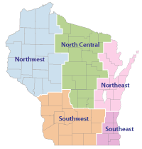
Pages: Southwest | Southeast | Northeast | North Central | Northwest

Ashland, Barron, Bayfield, Buffalo, Burnett, Chippewa, Clark, Douglas, Dunn, Eau Claire, Jackson, Pepin, Pierce, Polk, Rusk Sawyer, St. Croix, Taylor, Trempealeau and Washburn counties Columbia, Crawford, Dane, Dodge, Grant, Green, Iowa, Jefferson, Juneau, La Crosse, Lafayette, Monroe, Richland, Rock, Sauk and Vernon counties Kenosha, Racine, Milwaukee, Ozaukee, Walworth, Washington and Waukesha counties Brown, Calumet, Door, Fond du Lac, Kewaunee, Manitowoc, Marinette, Oconto, Outagamie, Sheboygan and Winnebago counties Adams, Florence, Forest, Green Lake, Iron, Langlade, Lincoln, Marathon, Marquette, Menomonee, Oneida, Portage, Price, Shawano, Vilas, Waupaca, Waushara and Wood counties

In 2005, WisDOT reorganized their internal structure from eight districts into five regions. The Connecting Highways pages are now also organized by the same regional sturcture. Choose from one of the five region links above or click on the region map to the right.

For more information on WisDOT's region structure, see their Division of Transportation System Development (DTSD) Region offices page.