
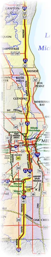
Milwaukee Freeways: North-South Freeway
 The
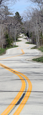
North-South Freeway is a major route in the Greater Milwaukee area, traveling
along a north-south alignment from Racine and Kenosha Counties on the south,
northerly through the entirety of Milwaukee County, bypassing downtown Milwaukee
to the west, and continuing into Ozaukee County. Unlike several other Milwaukee
area freeways, the North-South was completed in its entirety as originally
designed and is also part of the Interstate highway system, designated as I-43 from north of the city southerly to the Marquette Interchange downtown, as I-94/I-43 between the Marquette and Mitchell interchanges, and as I-94/I-41/US-41 from the Mitchell Interchange southerly.
The
North-South Freeway is a major route in the Greater Milwaukee area, traveling
along a north-south alignment from Racine and Kenosha Counties on the south,
northerly through the entirety of Milwaukee County, bypassing downtown Milwaukee
to the west, and continuing into Ozaukee County. Unlike several other Milwaukee
area freeways, the North-South was completed in its entirety as originally
designed and is also part of the Interstate highway system, designated as I-43 from north of the city southerly to the Marquette Interchange downtown, as I-94/I-43 between the Marquette and Mitchell interchanges, and as I-94/I-41/US-41 from the Mitchell Interchange southerly.
Historically, a north-south trending freeway was part of even the earliest Milwaukee County freeway proposals, although the route has wandered back and forth a bit over the years before actual construction began. One early proposal was to route the freeway along the 16th St corridor, beginning at Pulaski Park on the south and heading northerly via the 16th St Viaduct over the Menomonee Valley, ending at Union Cemetery on the north. Later, the freeway was proposed to begin at Layton Ave, still in the 16th St corridor, northerly to National Ave where it was to turn northeasterly across the Menomonee Valley to the Central (now Marquette) Interchange, before turning northerly again. This plan actually featured a low-level bascule (draw) bridge over the Menomonee River, but planners decided the costs in terms of homes to be removed was too great and shifted the alignment to the east along the 4th St corridor. Thus, the now infamous "Plainfield Curve" just east of the Mitchell Interchange came into being. South of the Mitchell Interchange, the I-94/I-41/US-41/North-South Freeway actually runs along the 16th St corridor.
North of downtown Milwaukee, the North-South Freeway displaced thousands of homes as well as Borchert Field, Milwaukee's professional baseball stadium for a time. Once Milwaukee County Stadium was completed and opened on April 6, 1953, the older 14,000-seat park, originally known as Athletic Park and built in 1888, was torn down to make way for the planned freeway.
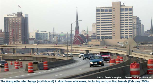
The Marquette (originally Central) Interchange sits atop the former neighborhood of Tory Hill. That entire neighborhood was removed to build the interchange in the 1960s. The final acquisition for the interchange project was wrapped up in 1967 when Cutler-Hammer received a sizeable settlement ($3.5 million) for their property. Today, the Tory Hill name survives as the name of the street built as part of the Marquette Interchange project, connecting Clybourn St west of 13th St with Michigan St east of 10th.
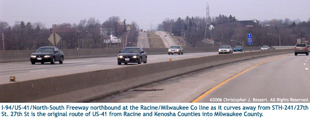
While planning for the freeway through Greater Milwaukee was underway, what would later be the southerly extension of the North-South Freeway through Kenosha and Racine Counties was completed as part of I-94 in 1959. That year, the route of US-41 from the Illinois state line northerly to 7 Mile Rd at the Racine/Milwaukee County line was converted from the 1940s four-lane divided highway to a full freeway facility with frontage roads.
The first segment of the North-South Freeway within Milwaukee County itself was completed and opened to traffic in 1963, running from STH-190/Capitol Dr northerly to CTH-PP/Good Hope Rd. This portion of the North-South was signed as part of US-141 at this time. A year later, another 1.4 miles of the US-141/North-South Freeway were completed from STH-190/Capitol Dr southerly to the Locust St interchange. This also marked the first time US-141 existed south of Capitol Dr since 1950. The freeway was extended southerly by another 7/10th mile from Locust St to North Ave north of downtown Milwaukee in 1964. From there, US-141 was routed southerly via Halyard St and 6th St to a terminus at US-18/State St. In addition, the divided highway portion of US-141 from CTH-PP/Good Hope Rd northerly to STH-100/Brown Deer Rd was converted to full freeway standards as a northerly extension of the North-South Freeway.
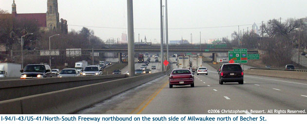
In 1966, the I-94/North-South Freeway was completed and opened to traffic from the Racine/Milwaukee County line northerly through the Mitchell Interchange to a temporary terminus at Holt Ave in south Milwaukee. The next year, with I-94 nearing completion in the state, the segment of the North-South from Holt Ave on the south side of Milwaukee northerly to Becher St was completed. Additional progress was also made in 1967 on the north side of the metro region as the US-141/STH-32 freeway was completed from STH-100/Brown Deer Rd northerly to present-day Exit 93 at jct STH-57 [South] & STH-32 [North] near Grafton. The former route of US-141 along Port Washington Rd was turned back to county control as CTH-W.
The final link in the North-South Freeway in Milwaukee County was completed in early 1969, including the massive Marquette Interchange downtown. The North-South now ran from the Illinois state line to STH-32 [North] near Grafton. Indeed, the I-94 freeway from Becher St northerly through the Marquette and westerly past 13th St becomes the last link in I-94 in Wisconsin, allowing motorists to drive on that route from the Illinois state line to the Saint Croix River for the first time, non-stop. Similarly, the monstrous Marquette Interchange is the final link in both the North-South and the East-West Freeways. The route of US-141 now extended southerly to a terminus at the Marquette at jct I-94 & I-794.
A northerly extension of the US-141 freeway, signed only as part of STH-57 for the time being, was completed in 1972 from present-day Exit 93 at Grafton to STH-33 at Saukville. Then three years later in 1975, the US-141 freeway was completed and opened to traffic from STH-33 at Saukville northeasterly past Port Washington to Cedar Grove and, with that, I-43 debuted along the US-141/North-South Freeway from downtown Milwaukee at the Marquette Interchange northerly along the completed freeway to STH-23 at Sheboygan. This signaled the beginning of the end for US-141 in the area. Indeed, in 1977, the US-141 route marker symbols began disappearing from official WisDOT maps from Sheboygan southerly to Milwaukee. Sources indicate that US-141 similarly began disappearing from the I-43/North-South Freeway between Milwaukee and Grafton at this time. From the federal perspective, US-141 was officially truncated to Grafton in 1977 and, within a few years, would recede all the way back to Green Bay, leaving I-43 as the primary route designation along the North-South from downtown Milwaukee northerly.
In 1983, state Senator Mordecai Lee, an ardent opponent to all freeway construction, pushed a budget amendment through the legislature which forbade WisDOT from adding any additional travel lanes to the I-43/North-South Freeway from Bender Rd in Glendale to the Ozaukee County line. Lee was one of a group of staunch anti-freeway critics which campaigned for public office and won, taking their fights to the representative bodies at the municipal, county and state level. He also believed the freeways were simply fast routes for largely-white suburbanites to get to their jobs downtown and quickly home again, while tearing inner-city neighborhoods apart. Thus, even though all new freeway construction within Milwaukee County had come to an abrupt halt nearly a decade earlier, Lee was still actively campaigning against any improvement to even the existing corridors. The amendment he sponsored stayed on the books until it was repealed in the 1990s for the reconstruction of the Silver Spring Rd interchange.
On November 24, 1987, the North-South Freeway from the Marquette Interchange downtown to the Mitchell Interchange received another route designation: I-43. WisDOT had requested an Interstate designation for the Rock Freeway from Hales Corners to Beloit to replace the STH-15 designation. The FHWA agreed and extended I-43 all the way to Beloit. Thus, I-43 then piggybacked with I-94 along the North-South to the I-894/Airport Freeway, then westerly via the Airport to the Rock. I-43 route markers were posted during 1988.
Similarly in 1999, the I-94/North-South Freeway from the Racine/Milwaukee County line to the Marquette Interchange received yet another route designation: US-41. This was in response to neighborhood opposition to a project to reconstruct and widen a portion of existing US-41 along Layton Blvd in southern Milwaukee. The state ended up giving the boulevard to the city and relocated US-41 to the freeway routing through that part of the city. In 2004, the much-anticipated complete reconstruction of the downtown Marquette Interchange commenced and was completed and opened to traffic on August 19, 2008. Then in 2015, the 16 years of the North-South Freeway hosting the US-41 route designation between the Mitchell and Marquette Interchanges came to an end when US-41 and its new Interstate paring, I-41, were routed around the city via the Airport Freeway and Zoo Freeway.