
Wisconsin's Route Markers
From the earliest times of numbered and marked state trunk highways in Wisconsin, the standard state route marker has been the shape of a triangle, more or less. Early on, the triangle was taller than it was wide, had no horizontal rectangular element, and had the words "STATE TRUNK HIGHWAY " across the top and a stylized "WIS" under the route number. (See Standard Highway Markers: 1921 for photos of some of these signs.)
These early route markers would either be erected on stand-alone posts or on telephone and electric line poles along the highway. (Utility poles close by the side of the travelled-way were much more common in the first half of the 20th century.) By the 1930s, the rectangular "box" portion of the route marker had been added so that the route designation could be displayed with a larger font. The heading "WIS" was moved to the top of the triangle at this time.
In the early 1960s the traditional Wisconsin "cutout" triangle-and-rectangle was then incorporated with a square black sign "blank," as it is today. For more than three decades, the Wisconsin state highway marker has remained relatively unchanged.
This page attempts to illustrate the many and varies types of route markers used on Wisconsin's highways, from Interstate, US and State Trunk highways to National Forest routes, Great Lakes Circle Tours, Rustic Roads, county roads and others. Pick a type of route marker to jump directly to it:
Interstate | US Highway | State | County | Forest | Circle Tours | Other
Interstate Highway Markers |
|||
 |
 |
 |
 |
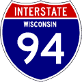
Original style Interstate
route marker adopted in the late 1950s and in use into the 1980s. |
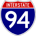
Newer-style Interstate
route marker omits the state name, allowing for larger and easier-to-read
numerals. |
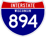
Original style 3-Digit
Interstate route marker adopted in the late 1950s and in use into
the 1980s. |
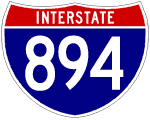
Newer-style
3-Digit Interstate route marker omits the state name, allowing
for larger and easier-to-read numerals. |
US Highway Markers |
|||
 |
 |
 |
 |
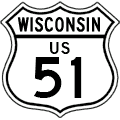
Original style
US Highway route marker adopted in the mid-1920s and in use into
the 1940s. |
Intermediate
style US Highway route marker adopted in the 1940s and in use into
the 1950s. |
A more major
redesign of the US Highway marker in Wisconsin in the early 1960s
placed the marker onto a black "sign blank." |
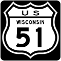
Another tweak to the
US Highway marker in Wisconsin around 1965-66 coincided with a similar
redesign of the State Trunk Highway marker. |
 |
 |
||
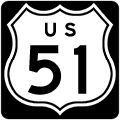
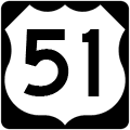
Beginning around 1973-74,
US Highway markers began appearing on square black "sign blanks" and
continue as such today. |
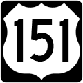
The modern-day three-digit
US Highway route marker, also adopted around 1973-74. |
||
State Trunk Highway Markers |
|||
 |
 |
 |
 |
The earliest
known version of the Wisconsin state trunk highway marker, this
one from a 1921 illustration. (More
marker photos from this timeframe.) |
This image
appeared on Rand McNally & Co. "Junior Auto Trails" maps
of Wisconsin in the early 1920s, illustrating a state highway
marker posted on a utility pole. |
In c.1927,
about the time the first US Highways were being signed, the words "STATE
TRUNK HIGHWAY"
were removed from the top of the state highway marker. |
In a makeover
of the state highway route marker from c.1938, a rounded-corner
rectangle was added atop the familiar triangle and the "WIS" legend
was moved to the top. |
 |
 |
 |
 |
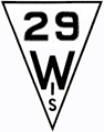
By the 1950s, the
route number typeface had been updated to use the standard
'FHWA' numerals. Otherwise, the marker remained unchanged from 1938. |
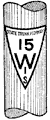
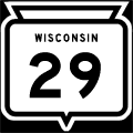
The first Wisconsin
state highway marker to appear on a black "sign blank," from
around 1965-66. For the only time, the entire state name appeared
on the marker itself. |
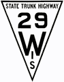
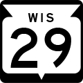
The next changes
included removing the horizontal line separating the triangle and
rectangle, removing the outline and shortening the state name to "WIS". |
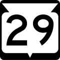
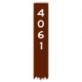
The current
state trunk highway route marker. Only the legend "WIS" was
removed and the route number moved up from the previous version. |
County Trunk Highway Markers |
|||
 |
 |
 |
|
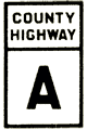
An early version of the County
Trunk Highway marker used through the 1930s, 40s and 50s. |
The first County Trunk Highway
marker to appear on a black "sign blank" assumedly from the 1960s. |
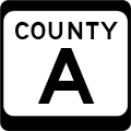
The current County Trunk
Highway route marker used statewide. |
|
Federal Forest Highway & Forest Road Markers | |||
 |
 |
 |
|
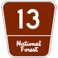
Federal Forest Highway route markers
appear in Wisconsin's national forests. These are high-quality,
well-maintained (usually all-weather) highways. |
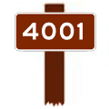
Secondary Forest Road sign,
used on roads generally open to automobile travel and closed to
ORV use. These roads can range from paved to one-lane gravel. |
Low-Standard Forest Road
signs are used for roads which may be open to motorized use or
may be closed to all but ORV or foot traffic. These range from
one-lane gravel to two-track. |
|
Great Lakes Circle Tour Markers & Scenic Byway Marker |
|||
 |
 |
 |
 |
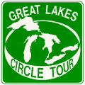
The Great Lakes Circle Tour sign,
used very sparingly in Wisconsin, although it does appear once in
awhile. |
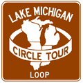
The Lake Michigan Circle
Tour route marker is found along many miles of Wisconsin highways. |
The Lake Michigan Circle Tour
Loop route marker is used for loops off the mainline Circle Tour
route. |
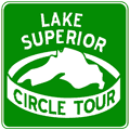
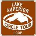
The Lake Superior Circle
Tour route marker appears along several Northern Wisconsin highways. |
 |
 |
||
The Lake Superior Circle Tour
Loop route marker is used for loops off the mainline Circle Tour
route. |
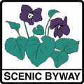
The Scenic Byway route marker made its debut along designated scenic or historic state trunk highways in 2005. |
||
Other Route Markers |
|||
 |
 |
 |
 |
The Great River Road stretches
from the Gulf of Mexico into Ontario, touching Wisconsin en route. |
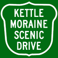
The 115-mile long
Kettle Moraine Scenic Drive traverses six Southeastern Wisconsin
counties and uses this route marker. |
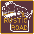
The more than 100 Rustic
Roads in all corners of the state use this route marker. A supplementary
Rustic Road Number plate is affixed below the sign designating
each route by number. |
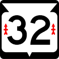
While largely the same as
standard state route markers, the marker for STH-32 includes
two small "Red
Arrows" memorializing
the 32nd "Red Arrow" Division. |
Acknowledgements:
Nearly every route marker image above was created by Christopher J. Bessert and, therefore, are copyrighted ©2004–2016 Christopher J. Bessert, All Rights Reserved. Please do not reproduce or otherwise use them without prior written permission. Any commercial use is strictly prohibited.
However, some acknowledgements and credit are necessary.
- Many thanks to Michael Adams and his "Roadgeek" typeface series used to create many of these route markers.
- Additional thanks to Bruce S Cridlebaugh and his "USHighwaysOldStyle" typeface used for the 'original style' US route markers.
- Richard C. Moeur's "Sign Manual" website provided a few of the graphic bases used in creating these markers.
- James Lin's "Highway Route Markers" website provided much inspiration.
- The 1921 and 1938 state trunk highway route markers and the earliest version of the county trunk highway marker were modified from scans of images from early Wisconsin Highway Commission maps and publications.
- The second earliest state trunk highway markers ("STH-15") was reproduced from a Rand McNally & Co. "Junior Auto Trails Map of Wisconsin," 1924.
- Many thanks to John Repp who provided photos of older versions of the Wisconsin US Highway marker and other guidance for this page.
Additional Information:
For more information on Wisconsin's state highway (and other) route markers, visit the following off-site sources:
- Standard Highway Markers: 1921 – an excerpt of photographic representations of the standard highway markers on Wisconsin's state highways from 1921.
- Highway Route Markers by James Lin, features highway markers from the US, Canada, Asia, Australia, Europe and Mexico.
- About Via: Signs – the Signs category listing from the About Via website.
- Road Signs of Wisconsin – photos of current and historic Wisconsin route markers from Mark O'Neil's Road Signs website.