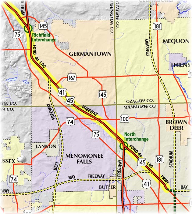
Milwaukee Freeways: Fond du Lac Freeway
The Fond du Lac Freeway runs on an angular northwesterly-southeasterly alignment in the northwestern portion of the City of Milwaukee, parallel to its namesake, Fond du Lac Ave. This freeway segment, designated STH-145, begins where it diverges from Fond du Lac Ave near 68th St (just north of CTH-EE/Hampton Ave) and continues northwesterly to the North Interchange where it meets I-41/US-41/US-45/STH-100/Zoo Freeway. In addition, some sources also indicate the I-41/US-41/US-45 freeway leading northwesterly away from the North Interchange toward the Richfield Interchange is also part of the Fond du Lac Freeway, which could likely be the case either officially or historically. However, in popular modern usage, the name "Fond du Lac Freeway" is generally applied today only to the portion of STH-145 from 68th St to the North Interchange.
Historically, the predecessor to the Fond du Lac Freeway was called the Northwest Expressway in the earliest Milwaukee expressway plans from the early 1950s. It ran along the Fond du Lac Ave corridor from the northwest portion of the city before turning southerly along the corridor later proposed for the Stadium Freeway (North) to end at the East-West Freeway. In the later freeway system plans, the Fond du Lac Freeway was to begin at the interchange of the Stadium Freeway and the Bay Freeway in the area of the CTH-EE/Hampton Ave & 60th St intersection and run northwesterly toward Menomonee Falls and Germantown.
Construction on the Fond du Lac Freeway actually predates the freeway system. What is now the I-41/US-41/US-45 freeway from the Granville area northwesterly to the US-41/US-45 "split" (Richfield Interchange) in Washington Co was completed as a divided highway in 1953. It was not until the 1980s that this portion of US-41/US-45 was converted to full freeway standards with the elimination of the last crossroad intersections.
Work on what most Milwaukeeans know as the Fond du Lac Freeway began in the mid-1960s and was complete in 1967 when the freeway from 68th St northwesterly to the North Interchange was opened to traffic. After that portion of the freeway was complete, the rising tide of opposition to additional mileage within the City of Milwaukee stalled any further progress at 68th St. The same sentiment which cancelled the Stadium Freeway (North and South) the Park Freeway West, the Bay Freeway, the Downtown Loop Closure and the Lake Freeway South extension was also the death knell for any further extension of the Fond du Lac. There was a proposal in the early 1970s by lawmakers to complete just link between the stub ends of the Fond du Lac and the Stadium (North), dubbed the "Gap Closure Freeway," but this idea gained no traction in the divisive era of freeway opposition. Thus, the ends of both freeways still stare at each other from opposite sides of the four mile gap.
Note: The map below will be updated in the near future to show the many route designation changes from 2015.