
Milwaukee Freeways: Stadium Freeway
 The
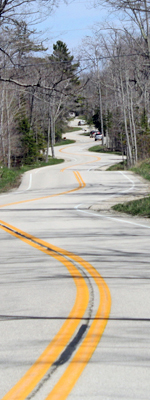
modern-day Stadium Freeway is a short, 1.9-mile long freeway bearing the STH-175 route designation (US-41 until 2015) running from the Stadium Interchange at the junction
of I-94/East-West
Freeway northerly to a terminus at Lisbon Ave north of
Washington Park in western Milwaukee. This segment of freeway is commonly
referred to as the "Stadium North." Until the late-1990s, the Stadium
Freeway name also extended to the south for an additional 9/10th mile past
the former Milwaukee County Stadium along the present-day Miller Park Way
corridor, with this segment being referred to as the "Stadium South." However,
as with several other freeways in the Milwaukee area, the completed portion
of the Stadium is but a small part of what had been proposed.
The
modern-day Stadium Freeway is a short, 1.9-mile long freeway bearing the STH-175 route designation (US-41 until 2015) running from the Stadium Interchange at the junction
of I-94/East-West
Freeway northerly to a terminus at Lisbon Ave north of
Washington Park in western Milwaukee. This segment of freeway is commonly
referred to as the "Stadium North." Until the late-1990s, the Stadium
Freeway name also extended to the south for an additional 9/10th mile past
the former Milwaukee County Stadium along the present-day Miller Park Way
corridor, with this segment being referred to as the "Stadium South." However,
as with several other freeways in the Milwaukee area, the completed portion
of the Stadium is but a small part of what had been proposed.
Approximately half of what would become the proposed Stadium Freeway debuted in the early 1950s Milwaukee County Expressway Plan, although at the time it was divided into two separate freeways. From the proposed East-West Expressway at an interchange near the brand-new Milwaukee County Stadium, the South 44th Street Expressway was planned to run southerly along the 44th St corridor to the proposed Howard Street Expressway, which would have run easterly to the North-South Expressway in the 16th St corridor with an future extension westerly to the planned West Expressway (now the Zoo Freeway). From the East-West northerly, the Northwest Expressway was planned to travel to an interchange with the North Avenue Expressway (later to be reworked as the Park Freeway West) where it would have turned northwesterly to leave the city roughly along the Appleton Ave corridor.
Even as the overall Milwaukee County freeway system was still being planned, the very first segment of freeway in the city was completed and opened to traffic in 1953. It was a 2,200-foot long segment of four-lane freeway in the S 43rd St corridor beginning at STH-59/National Ave and continuing northerly just east of the new Milwaukee County Stadium.
As the first segment of what would become the Stadium Freeway was opening to traffic, the southern end of the route at National Ave was aimed directly into the City of West Milwaukee. Up to this point, the it was the City of Milwaukee that had taken on the job of constructing the freeway system, but it was becoming clear that the City would have a rather difficult time of trying to push one of "its" freeways through another municipality's territory. The City of West Milwaukee was similarly unhappy with the prospect of its neighboring "big brother" displacing a major portion of its own industrial tax base and was preparing to fight further progress on this new system of highways. However, knowing the situation may be turning against any further progress, the City of Milwaukee turned over all planning, coordination and building of the freeway network to the newly-created Milwaukee County Expressway Commission in 1954.
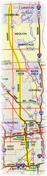
The County began planning in earnest for the new freeway system and the short 2,200-foot freeway segment near the stadium was incorporated into a freeway to begin at the planned Airport Freeway in Greenfield and continue northerly through West Milwaukee, interchanging with the East-West Freeway before continuing northerly to what would become the Park Freeway. During the early 1960s, the Southeastern Wisconsin Regional Planning Commission (SEWRPC) was created and that new body took over planning of the freeways in the greater Milwaukee area. SEWRPC took the original Stadium Freeway and tripled its length with a northerly extension from the Park Freeway through the north portion of Milwaukee, passing through Brown Deer before entering Ozaukee Co and continuing northerly bypassing Theinsville, Cedarburg and Grafton to the west. The new Stadium North extension would then curve to the northeast to meet up with the North-South Freeway and the Port Washington Bypass at a major interchange at Saukville.
Meanwhile, progress on the "original" segment of the Stadium continued. In 1961, the I-94/East-West Freeway was opened through the yet-uncompleted Stadium Interchange and a year would pass until the portion of the Stadium Freeway from the Stadium Interchange northerly to Lisbon Ave would be completed and opened to traffic. It was 1962 and, unbeknownst at the time, no other portion of the Stadium would ever be built, although it take many years to completely remove all portions of the un-constructed freeway from most planning maps.
As the optimistic mid-1960s, in terms of freeway building, turned into the turmoil of the late-1960s and early-1970s, work continued on other major segments of freeway around the greater Milwaukee region, but no progress was made on completing the Stadium. In 1974, in response to mounting criticism, increasing opposition and evaporating funding, the Milwaukee County Expressway Commission cancelled the Stadium Freeway North from Lisbon Ave northerly toward Ozaukee County, also effectively canceling the Ozaukee County portion as well. The Stadium South, however, was still on the books but mired in the same controversy plaguing the Park Freeway West, Lake Freeway South and the Downtown Loop Closure.
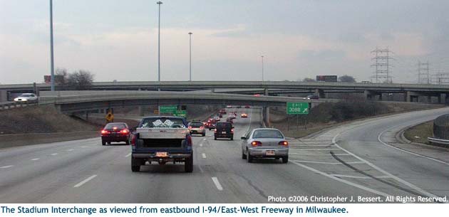
 With the Park
Freeway West between the I-43/North-South
Freeway and the
northern end of the completed Stadium Freeway in a very precarious position—the
Park's Environmental Impact Statement was recently completed and submitted
to the federal government—Milwaukee County Executive John Doyne proposed
the so-called "gap-closure freeway" in September 1975. The "gap-closure" resurrected
the recently-cancelled Stadium North from Lisbon Ave northerly to the end
of the Fond du Lac Freeway at N 68th St. One of the criticisms of the Park
Freeway West EIS was that it would only connect with the Stadium Freeway
North stub and be of very little utility. It seems the "gap-closure
freeway" was, in part, in response to this evaluation of the Park
West,
but nothing ever came of it and the Stadium North extension was again shelved.
With the Park
Freeway West between the I-43/North-South
Freeway and the
northern end of the completed Stadium Freeway in a very precarious position—the
Park's Environmental Impact Statement was recently completed and submitted
to the federal government—Milwaukee County Executive John Doyne proposed
the so-called "gap-closure freeway" in September 1975. The "gap-closure" resurrected
the recently-cancelled Stadium North from Lisbon Ave northerly to the end
of the Fond du Lac Freeway at N 68th St. One of the criticisms of the Park
Freeway West EIS was that it would only connect with the Stadium Freeway
North stub and be of very little utility. It seems the "gap-closure
freeway" was, in part, in response to this evaluation of the Park
West,
but nothing ever came of it and the Stadium North extension was again shelved.
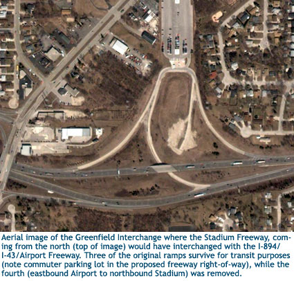
Attention turned to the Stadium Freeway South completion from STH-59/National Ave to the I-894/Airport Freeway when on January 3, 1977, Governor Patrick Lucey halted all further construction on that segment of freeway after reportedly receiving a letter from the primary anti-freeway legislators. While some of the right-of-way for this freeway had been purchased and cleared, much like that of the Park West, a ten-year moratorium on all new freeway construction had been hammered out by freeway opponents and this action on the part of Lucey merely made it official that the Stadium South was to suffer the same fate as several other Milwaukee area freeways. The doubly-stub-ended Stadium Freeway would remain as-is for the next two decades.
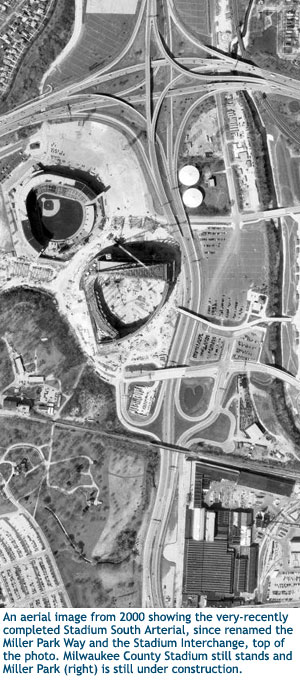 To accommodate the construction of Miller Park, the replacement for Milwaukee
County Stadium, in the late-1990s, the portion of the Stadium South from
the I-94/East-West
Freeway to STH-59/National Ave was closed and completely
reconstructed, moving the entire highway to the east, bending around the
footprint of the new ballpark. It was closed in November 1996 with demolition
commencing very soon after and the reconfigured facility reopened to traffic
on August 6, 1998. The $18.1-million project resulted in a roadway that,
while not officially a freeway, is completely-limited access and entry is
only gained through interchanges or at the highway's southern end at National
Ave. A 45-mph speed limit was the most noticeable difference to motorists,
however. When reopened, the highway was titled the Stadium South "Arterial" instead
of the Stadium South Freeway until the completion of Miller Park. Since that
time, it has been officially named the Miller Park Way.
To accommodate the construction of Miller Park, the replacement for Milwaukee
County Stadium, in the late-1990s, the portion of the Stadium South from
the I-94/East-West
Freeway to STH-59/National Ave was closed and completely
reconstructed, moving the entire highway to the east, bending around the
footprint of the new ballpark. It was closed in November 1996 with demolition
commencing very soon after and the reconfigured facility reopened to traffic
on August 6, 1998. The $18.1-million project resulted in a roadway that,
while not officially a freeway, is completely-limited access and entry is
only gained through interchanges or at the highway's southern end at National
Ave. A 45-mph speed limit was the most noticeable difference to motorists,
however. When reopened, the highway was titled the Stadium South "Arterial" instead
of the Stadium South Freeway until the completion of Miller Park. Since that
time, it has been officially named the Miller Park Way.
In 1999, Miller Park Way (then still the Stadium South Arterial) lost its U.S. Highway designation when US-41 was removed from its surface-street routing from the Racine/Milwaukee County line northerly via S 27th St, Layton Blvd and National Ave and relocated onto the North-South and East West Freeways, remaining with I-94 that entire distance to the Stadium Interchange. This was in response to a battle between WisDOT, the City of Milwaukee and local citizens who protested the state's plans to reconstruct and widen Layton Blvd through a portion of the city. The resolution finally reached included allowing the City to rebuild the highway without widening it, but that stretch would lose its state trunkline status and the US-41 designation was moved onto the freeway routing. The Stadium South (Miller Park Way) officially became STH-341, but WisDOT chose not to sign it as such in the field, instead leaving all signs pointing to it simply as "Miller Park Way."
In 2015, major highway route designations throughout Greater Milwaukee resulted from the debut of I-41 between the Illinois state line and Green Bay. To accommodate the unique pairing ofI-41 with US-41, the route of the latter was adjusted to bypass the city along I-894 using the Airport Freeway and Zoo Freeway. The US-41 designation was simply removed from the I-94/I-43/North-South Freeway between the Mitchell and Marquette Interchanges and from the I-94/East-West Freeway from the Marquette westerly to the Stadium Interchange. The route of US-41 along the Stadium North Freeway and surface streets through northwest Milwaukee was redesignated as an extension of STH-175. Simultaneously, the unsigned and unposted STH-341 designation along Miller Park Way from I-94 southerly to STH-59/National Ave was also resdesignated as part of STH-175 as well.
While it would seem the northern end of the Stadium Freeway is forever cemented at Lisbon Ave in the hearts and minds of all parties concerned, WisDOT's "Official State Trunk Highway System Maps," interestingly still contains a "mapped corridor" for STH-175 (formerly US-41 until 2015) through the near northwest side of the City of Milwaukee, roughly along the line of the cancelled Stadium Freeway North. While most other originally "mapped corridors" have been erased from the trunkline system maps (sometimes through the enactment of legislation to that effect), this one corridor has been allowed to remain as a dashed line connecting the northern stub end of the never-completed Stadium Freeway with the southern end of the STH-145/Fond du Lac Freeway, running parallel to W Lisbon Ave and Appleton Ave to 60th St, then following 60th St northerly to Fond du Lac Ave. While WisDOT has absolutely no plans to ever bring back Milwaukee County Executive John Doyne's 1975 plan for the "gap-closure freeway," it oddly still remains a mapped corridor on the official maps at the state level.